Mitch Blank's North-German Genealogy Site

Let me know if we are researching the same people or places.


Name and place indexes for this entire web site.

Introduction to this web site.
Copyright ©1998-2018 by Mitch Blank
Bruss
(Now Brusy)
Kreis Konitz, West Prussia
Related Families in Bruss
Navigation
Let me know if we are researching the same people or places.
Name and place indexes for this entire web site.
Introduction to this web site.
This page created March 16th, 2018, edited March 20th, 2018
Kreis Konitz, West Prussia
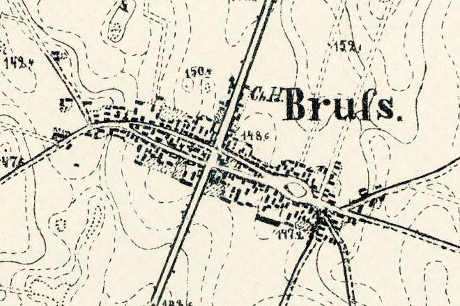
Map dates from 1874. It covers an area of approximately 1.3 by 0.8 km (0.8 by 0.5 US miles).
Map image was adapted from 1:25K Prussian Landsaufnahme, page 2172, Bruss
The following table shows which of the individuals included in this web site are connected to Bruss and over what time span they are found here.
| Surname | Given names and the range of dates the person was found in Bruss |
|---|---|
| Bruska |
 Theresia 1828..1833 Theresia 1828..1833 |
| Herkowski / H(i/y)rkowsk(a/i) |
 Agnes 1828Anna 1833Antonina 1862Franz 1831..1863Jacob 1828..1833Simon 1829Stephan 1863 Agnes 1828Anna 1833Antonina 1862Franz 1831..1863Jacob 1828..1833Simon 1829Stephan 1863 |
| Lipska / Lipski |
Andreas 1843Johann 1833..1843Marcianna 1834..1863Marianna 1833Marianna 1840 |
| Mecikalski |
 Simon 1852 Simon 1852 |
| Sieracka |
Antonina 1833..1843 |