Mitch Blank's North-German Genealogy Site

Let me know if we are researching the same people or places.


Name and place indexes for this entire web site.

Information on just Kreis Greifenberg, Pommern.

Introduction to this web site.
Copyright ©1998-2019 by Mitch Blank
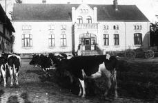
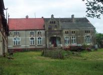
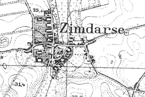
Zimdarse
(Now Siemidarzno)
Kreis Greifenberg, Pommern
(Click on picture for larger image)
Related Families in Zimdarse
Navigation
Let me know if we are researching the same people or places.
Name and place indexes for this entire web site.
Information on just Kreis Greifenberg, Pommern.
Introduction to this web site.
This page created September 16th, 2002, updated July 30th, 2018, last edited August 21st, 2019
Kreis Greifenberg, Pommern
(Click on picture for larger image)
| |
| To zoom out to a larger area map click here. | |
|---|---|
Map dates from 1891, updated 1941. It covers an area of approximately 1.3 by 0.8 km (0.8 by 0.5 US miles).
Map image was adapted from 1:25K Prussian Landsaufnahme, page 1958
The following table shows which of the individuals included in this web site are connected to Zimdarse and over what time span they are found here.
| Surname | Given names and the range of dates the person was found in Zimdarse |
|---|---|
| Benz / Bentz |
 Dorothea 1845..1883 Dorothea 1845..1883 Dorothea 1843Johann Friedrich 1845 Dorothea 1843Johann Friedrich 1845 |
| Halbreder |
Sophia Friederica 1835 |
| Polzin/Poltzin |
 Emilie Albertine 1845Johann 1827..1872Johann August 1851..1852Johann Martin Ferdinand 1853Sophie Marie 1846Wilhelmine Therese 1848Wilhemine Friederike 1845 Emilie Albertine 1845Johann 1827..1872Johann August 1851..1852Johann Martin Ferdinand 1853Sophie Marie 1846Wilhelmine Therese 1848Wilhemine Friederike 1845 |
| Rüge |
 Friederike Wilhelmina 1838..1841Johann 1827..1847Peter 1787 Friederike Wilhelmina 1838..1841Johann 1827..1847Peter 1787 |
| Treptow |
Sophia 1838..1852 |