Mitch Blank's North-German Genealogy Site

Let me know if we are researching the same people or places.


Name and place indexes for this entire web site.

Information on just Kreis Greifenberg, Pommern.

Introduction to this web site.
Copyright ©1998-2019 by Mitch Blank
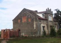
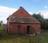
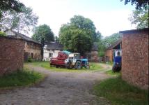
Küssin
(Now Kusin)
Kreis Greifenberg, Pommern
(Click on picture for larger image)
Related Families in Küssin
Navigation
Let me know if we are researching the same people or places.
Name and place indexes for this entire web site.
Information on just Kreis Greifenberg, Pommern.
Introduction to this web site.
This page created March 23rd, 2000, updated October 25th, 2014, last edited April 14th, 2019
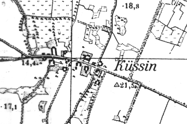
Kreis Greifenberg, Pommern
(Click on picture for larger image)
| |
| To zoom out to a larger area map click here. | |
|---|---|
Map dates from 1891, updated 1941. It covers an area of approximately 1.3 by 0.8 km (0.8 by 0.5 US miles).
Map image was adapted from 1:25K Prussian Landsaufnahme, page 1956
The following table shows which of the individuals included in this web site are connected to Küssin and over what time span they are found here.
| Surname | Given names and the range of dates the person was found in Küssin |
|---|---|
| Bonin |
 Dorothea 1775..1823 Dorothea 1775..1823 |
| Parpart / Par(b/p/pp)ar(d/t/dt/th) |
 Carl Friedrich Wilhelm 1815Catharine 1779 Carl Friedrich Wilhelm 1815Catharine 1779 Christine 1789..1815Dorothea Maria 1781Friedrich 1787..1820Hans 1715..1735Joachim 1792Jochen 1751..1825Louisa 1782Marie 1775Martin 1715..1754 Christine 1789..1815Dorothea Maria 1781Friedrich 1787..1820Hans 1715..1735Joachim 1792Jochen 1751..1825Louisa 1782Marie 1775Martin 1715..1754 |
| Radtke / Radke / Rathke |
 Johanna Friedericke 1815 Johanna Friedericke 1815 |