Mitch Blank's North-German Genealogy Site

Let me know if we are researching the same people or places.


Name and place indexes for this entire web site.

Information on just Kreis Greifenberg, Pommern.

Introduction to this web site.
Copyright ©1998-2019 by Mitch Blank
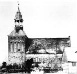
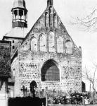
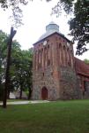
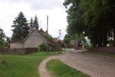
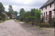
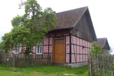
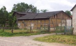
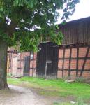
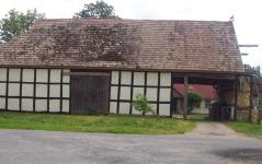
Gützlaffshagen
(Now Goslaw)
Kreis Greifenberg, Pommern
(Click on picture for larger image)
Related Families in Gützlaffshagen
Navigation
Let me know if we are researching the same people or places.
Name and place indexes for this entire web site.
Information on just Kreis Greifenberg, Pommern.
Introduction to this web site.
This page created March 25th, 2000, updated August 4th, 2018, last edited August 20th, 2019
Kreis Greifenberg, Pommern
(Click on picture for larger image)

| |
| To zoom out to a larger area map click here. | |
|---|---|
Map dates from 1891, updated 1941. It covers an area of approximately 3.2 by 2.1 km (2.0 by 1.3 US miles).
Map image was adapted from 1:25K Prussian Landsaufnahme, page 1958
The following table shows which of the individuals included in this web site are connected to Gützlaffshagen and over what time span they are found here.
| Surname | Given names and the range of dates the person was found in Gützlaffshagen |
|---|---|
| Arndt |
 Engel 1825..1832Sophia 1810..1857 Engel 1825..1832Sophia 1810..1857 |
| Benz / Bentz |
 August Ferdinand 1853 August Ferdinand 1853 Caroline Wilhelmine 1849Caroline Wilhelmine Marie 1850..1852Dorothea 1815Dorothea 1813Emilie Wilhelmine 1861Ferdinand 1855Hermann Friedrich Albert 1858Johann 1823..1871Johann 1817..1819Johann 1812..1831Martin 1812..1820Mathilde Wilhelmine Dorothea 1871Otto Albert Ferdinand 1864Phillip 1831Wilhelm 1855 Caroline Wilhelmine 1849Caroline Wilhelmine Marie 1850..1852Dorothea 1815Dorothea 1813Emilie Wilhelmine 1861Ferdinand 1855Hermann Friedrich Albert 1858Johann 1823..1871Johann 1817..1819Johann 1812..1831Martin 1812..1820Mathilde Wilhelmine Dorothea 1871Otto Albert Ferdinand 1864Phillip 1831Wilhelm 1855 |
| Blank |
 Eduard August Friedrich 1855..1858Johanna Hedwig Angelina 1858Johannes Wilhelm Oskar 1856Ulrika Therses Amilie 1855..1858Wilhelm August 1855..1858 Eduard August Friedrich 1855..1858Johanna Hedwig Angelina 1858Johannes Wilhelm Oskar 1856Ulrika Therses Amilie 1855..1858Wilhelm August 1855..1858 |
| Brandt |
Anna 1823Maria 1814..1823 |
| Butzlaff |
Friederica Wilhelmine 1825..1851Johann 1825 |
| Genz |
Catharina 1812..1851Maria 1851Martin 1812..1832 |
| Heidemann / Heydemann |
Engel 1813..1847 |
| Hinkelmann |
Angelica Florentine 1855..1858 |
| Köhler |
Johann Gottlieb Herman 1864..1899 |
| Lüdke |
Catharina 1823 |
| Pagenkopf |
August 1837..1840Engel 1803Friederika 1834..1910Maria 1826..1832Maria 1840Martin 1824..1866Peter 1824..1865Sophie 1829..1871Wilhelmine 1832..1853 |
| Riess / Ries(c)h / Riehs |
Friederike Wilhelmine Charlotte 1843..1871Johann 1851Maria Wilhelmine 1851 |
| Scheibe |
Daniel 1828..1830Engel 1828..1850Friederica Wilhelmina Loisa 1828Wilhelm 1829 |
| Schmeigel / Schme(i)chel |
Catharina 1820..1897Christian 1820..1826Friedrich Wilhelm 1826..1878 |
| Schuster |
Catharina 1813..1881Gottlieb 1813 |
| Schwanz |
Albert Hermann 1848..1850Albert Ludwig 1854Albertine Wilhelmine 1843..1873August Gustav 1858..1862Engel 1821..1867Johann 1812..1858Johann Gottlieb 1845..1851Maria 1820..1826 |
| Sohrweide |
Albert Heinrich 1844..1874Albert Wilhelm 1863August Ferdinand Friedrich 1840Auguste Emilie 1863Caroline Sophie 1838..1899Emilie Beate 1841Friederike 1837Friedrich Wilhelm 1827..1856Johann Carl Wilhelm 1832Maria 1830..1833Maria 1834Wilhelmina 1828..1863 |
| Stegemann |
Dorothea Maria Friederica 1828..1829 |
| Storm |
Johann August 1864 |
| Tews |
Catharina 1824..1857Maria 1783..1821 |
| Treptow |
Dorothea 1823Hans 1732..1739Johann 1784..1847Johann 1816Johann 1819Johann 1810Johann 1811Johann 1819Johann 1760..1834Maria 1814..1835Maria 1829..1834Martin 1783..1834 Martin 1835Peter 1816..1885Peter 1732..1760Phillip 1813..1884Sophia 1790Sophia 1817Sophia 1821..1865Wilhelm 1825..1873Wilhelmina 1832..1889 Martin 1835Peter 1816..1885Peter 1732..1760Phillip 1813..1884Sophia 1790Sophia 1817Sophia 1821..1865Wilhelm 1825..1873Wilhelmina 1832..1889 |
| Volkmann |
Johann 1817 |
| Wendorf |
Ferdinand Wilhelm 1853Johann 1853 |