Mitch Blank's North-German Genealogy Site

Let me know if we are researching the same people or places.


Name and place indexes for this entire web site.

Information on just Kreis Greifenberg, Pommern.

Introduction to this web site.
Copyright ©1998-2019 by Mitch Blank
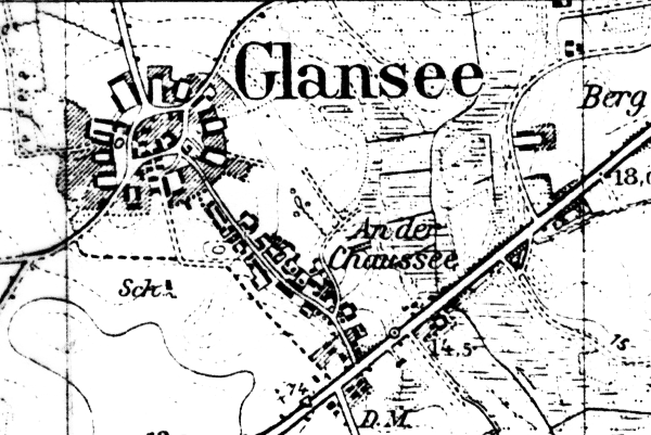
Glansee
(Now Goacz Pomorska)
Kreis Greifenberg, Pommern
Related Families in Glansee
Navigation
Let me know if we are researching the same people or places.
Name and place indexes for this entire web site.
Information on just Kreis Greifenberg, Pommern.
Introduction to this web site.
This page created August 24th, 2001, updated August 22nd, 2019, last edited August 26th, 2019
Kreis Greifenberg, Pommern
| |
| To zoom out to a larger area map click here. | |
|---|---|
Map dates from 1891, updated 1941. It covers an area of approximately 1.3 by 0.8 km (0.8 by 0.5 US miles).
Map image was adapted from 1:25K Prussian Landsaufnahme, page 1958
The following table shows which of the individuals included in this web site are connected to Glansee and over what time span they are found here.
| Surname | Given names and the range of dates the person was found in Glansee |
|---|---|
| Bergin |
 Wilhelmine 1818 Wilhelmine 1818 |
| Tews |
 Hans 1733..1811Hans 1732..1754 Hans 1733..1811Hans 1732..1754 Jacob 1769Johann 1812Maria 1760 Jacob 1769Johann 1812Maria 1760 |