Mitch Blank's North-German Genealogy Site

Let me know if we are researching the same people or places.


Name and place indexes for this entire web site.

Information on just Western Mecklenburg.

Introduction to this web site.
Copyright ©1998-2017 by Mitch Blank
Lutterstorf
Kreis Wismar, Mecklenburg-Schwerin
Related Families in Lutterstorf
Navigation
Let me know if we are researching the same people or places.
Name and place indexes for this entire web site.
Information on just Western Mecklenburg.
Introduction to this web site.
This page created May 2nd, 2008, updated May 4th, 2011
Kreis Wismar, Mecklenburg-Schwerin
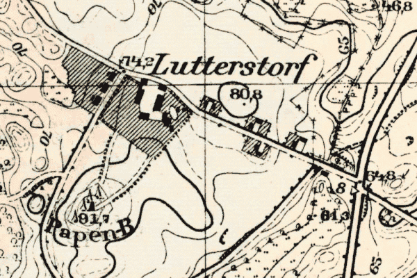
Map dates from 1879, updated 1943. It covers an area of approximately 1.3 by 0.8 km (0.8 by 0.5 US miles).
Map image was adapted from 1:25K Prussian Landsaufnahme, page 2134
The following table shows which of the individuals included in this web site are connected to Lutterstorf and over what time span they are found here.
| Surname | Given names and the range of dates the person was found in Lutterstorf |
|---|---|
| Burmeister |
 Anna 1889 Anna 1889 Anna Henriette Dorothea 1864..1867Carl Christian Wilhelm 1861..1889 Anna Henriette Dorothea 1864..1867Carl Christian Wilhelm 1861..1889 David Jochim Christopher 1853..1867Dorothea Sophie Marie 1854..1872Heinrich Christian Joachim 1855..1870Johann Heinrich Christian 1854Mina Caroline Louise Henriette 1858..1860 David Jochim Christopher 1853..1867Dorothea Sophie Marie 1854..1872Heinrich Christian Joachim 1855..1870Johann Heinrich Christian 1854Mina Caroline Louise Henriette 1858..1860 |
| Fischer |
 Wilhelmine Marie Dorothea 1889 Wilhelmine Marie Dorothea 1889 |
| Gosssel(c)k |
Friederica Caroline Dorothea 1854..1867Maria Sophia Anna 1854..1867Sophia Maria Louise 1900 |