Mitch Blank's North-German Genealogy Site

Let me know if we are researching the same people or places.


Name and place indexes for this entire web site.

Information on just Western Mecklenburg.

Introduction to this web site.
Copyright ©1998-2017 by Mitch Blank
Rampe
Kreis Schwerin, Mecklenburg-Schwerin
Related Families in Rampe
Navigation
Let me know if we are researching the same people or places.
Name and place indexes for this entire web site.
Information on just Western Mecklenburg.
Introduction to this web site.
This page created May 2nd, 2008, updated July 27th, 2008
Kreis Schwerin, Mecklenburg-Schwerin
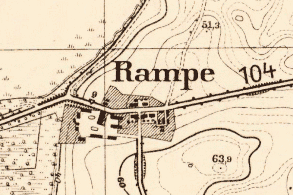
Map dates from 1881, updated 1940. It covers an area of approximately 1.3 by 0.8 km (0.8 by 0.5 US miles).
Map image was adapted from 1:25K Prussian Landsaufnahme, page 2334
The following table shows which of the individuals included in this web site are connected to Rampe and over what time span they are found here.
| Surname | Given names and the range of dates the person was found in Rampe |
|---|---|
| Hartig |
 Heinrich Carl Christopher 1820..1844Johann Friedrich Heinrich Christian 1844..1867 Heinrich Carl Christopher 1820..1844Johann Friedrich Heinrich Christian 1844..1867 Johann Joachim Carl David Friedrich 1834Louisa Sophia Johanna Henrica 1832..1867Maria Sophia Friederica 1840 Johann Joachim Carl David Friedrich 1834Louisa Sophia Johanna Henrica 1832..1867Maria Sophia Friederica 1840 |
| Kyp(c)k |
Johann David 1808..1867Johann Joachim Heinrich 1808..1827Sophia Maria Louisa 1808..1866 |
| Oldenburg |
 Johann Joachim Friedrich 1867 Johann Joachim Friedrich 1867 |
| Schröder |
Sophia Dorothea 1808..1847 |