Mitch Blank's North-German Genealogy Site

Let me know if we are researching the same people or places.


Name and place indexes for this entire web site.

Information on just this family and region.

Introduction to this web site.
Copyright ©1998-2017 by Mitch Blank
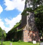
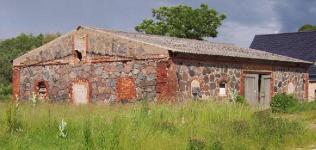
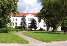
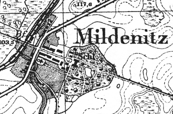
Mildenitz
Kreis Stargard, Mecklenburg-Strelitz
(Click on picture for larger image)
Related Families in Mildenitz
Navigation
Let me know if we are researching the same people or places.
Name and place indexes for this entire web site.
Information on just this family and region.
Introduction to this web site.
This page created August 1st, 2001, updated March 8th, 2013
Kreis Stargard, Mecklenburg-Strelitz
(Click on picture for larger image)
| |
| To zoom out to a larger area map click here. | |
|---|---|
Map dates from 1884, updated 1917/1932. It covers an area of approximately 1.3 by 0.8 km (0.8 by 0.5 US miles).
Map image was adapted from 1:25K Prussian Landsaufnahme, page 2547
The following table shows which of the individuals included in this web site are connected to Mildenitz and over what time span they are found here.
| Surname | Given names and the range of dates the person was found in Mildenitz |
|---|---|
| Koester / Köster / Küster |
 Johann Carl Friedrich 1827Johann Ephraim Christian 1823 Johann Carl Friedrich 1827Johann Ephraim Christian 1823 Johann Martin 1823..1830Wilhelm Christian Friedrich 1830 Johann Martin 1823..1830Wilhelm Christian Friedrich 1830 |
| Krüger |
 Christian 1767..1809Christian Ephraim 1767..1840 Christian 1767..1809Christian Ephraim 1767..1840 Christina Friederica 1807..1809Christine Sophie Charlotte 1811..1813Dorothea Sophia 1803..1830Ephraim 1769..1850Franz Wilhelm 1803..1819Friedrich Wilhelm Ludwig 1810Hanna Friederica Sophia 1807Hanna Maria Sophie 1822..1824Johann Andreas Franz 1812Johann Ephraim Franz 1814..1815Maria Christina 1805Maria Frederica Christiana 1805..1806Marie Charlotte Adolphine 1822Sophia Dorothea Carolina 1816..1820Wilhelm Christian Friedrich 1803 Christina Friederica 1807..1809Christine Sophie Charlotte 1811..1813Dorothea Sophia 1803..1830Ephraim 1769..1850Franz Wilhelm 1803..1819Friedrich Wilhelm Ludwig 1810Hanna Friederica Sophia 1807Hanna Maria Sophie 1822..1824Johann Andreas Franz 1812Johann Ephraim Franz 1814..1815Maria Christina 1805Maria Frederica Christiana 1805..1806Marie Charlotte Adolphine 1822Sophia Dorothea Carolina 1816..1820Wilhelm Christian Friedrich 1803 |
| Neuman(n) / Newman(n) |
Ephraim Adolpf Friedrich 1822Johann Friedrich 1822..1824Sophie Christine Friederike 1824 |
| Schöttler |
Carl Friedrich Wilhelm 1833 |
| Wenzel |
Charlotte 1803..1811 |
| Witt |
Charlotte Luise Florentine 1803..1822 |