Mitch Blank's North-German Genealogy Site

Let me know if we are researching the same people or places.


Name and place indexes for this entire web site.

Information on just Western Mecklenburg.

Introduction to this web site.
Copyright ©1998-2017 by Mitch Blank
Rastow
Kreis Ludwigslust, Mecklenburg-Schwerin
Related Families in Rastow
Navigation
Let me know if we are researching the same people or places.
Name and place indexes for this entire web site.
Information on just Western Mecklenburg.
Introduction to this web site.
This page created October 16th, 2007, updated August 29th, 2012
Kreis Ludwigslust, Mecklenburg-Schwerin
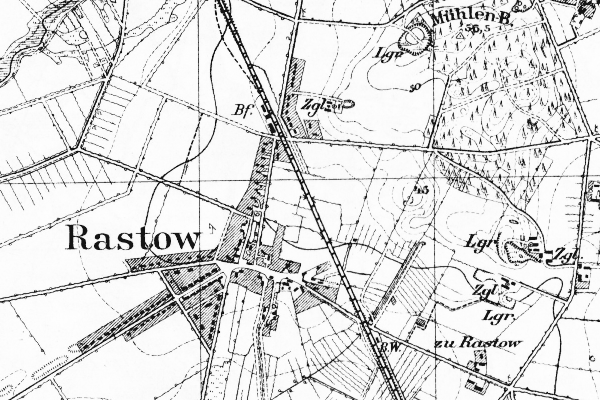
Map dates from 1904, updated 1919. It covers an area of approximately 2.5 by 1.7 km (1.6 by 1.1 US miles).
Map image was adapted from 1:25K Prussian Landsaufnahme, sheet 2534
The following table shows which of the individuals included in this web site are connected to Rastow and over what time span they are found here.
| Surname | Given names and the range of dates the person was found in Rastow |
|---|---|
| Klut(h) |
 Johann Christian 1751 Johann Christian 1751 |
| Rausch / Rusch |
 Anne Sophie 1720..1740 Anne Sophie 1720..1740 Christian 1661..1669Daniel 1671..1751Daniel 1655..1669Daniel 1611..1670Hans 1657..1669Hans Hinrich 1712..1752 Christian 1661..1669Daniel 1671..1751Daniel 1655..1669Daniel 1611..1670Hans 1657..1669Hans Hinrich 1712..1752 Hans Hinrich 1747Hans Jochim 1550..1585Hinrich 1644..1704Hinrich 1550..1570Joachim Christian 1742..1787Jochim 1580..1614Johann Friedrich 1749Johann Heinrich 1738Maria Lise 1744..1777Marie Helen 1714..1751Sophie 1665..1669Stoffer 1647..1704Trin 1653..1669 Hans Hinrich 1747Hans Jochim 1550..1585Hinrich 1644..1704Hinrich 1550..1570Joachim Christian 1742..1787Jochim 1580..1614Johann Friedrich 1749Johann Heinrich 1738Maria Lise 1744..1777Marie Helen 1714..1751Sophie 1665..1669Stoffer 1647..1704Trin 1653..1669 |
| Sottorffs |
Ann 1644..1670 |
| Vick |
Maria Dorothea 1738..1751 |