Mitch Blank's North-German Genealogy Site

Let me know if we are researching the same people or places.


Name and place indexes for this entire web site.

Introduction to this web site.
Copyright ©1998-2017 by Mitch Blank
Wilhelmshof
(Wilhelmshof bei Geswalde)
Kreis Uckermark/Templin, Brandenburg
(Click on picture for larger image)
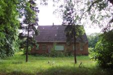
Wilhelmshof was a small settlement dating from ca 1800, surrounded by forest. In 1853 it consisted of three residences plus four other buildings and was the home for 36 people.
Related Families in Wilhelmshof
Navigation
Let me know if we are researching the same people or places.
Name and place indexes for this entire web site.
Introduction to this web site.
This page created August 29th, 2013, edited February 24th, 2017
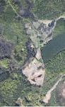
Kreis Uckermark/Templin, Brandenburg
(Click on picture for larger image)
Wilhelmshof was a small settlement dating from ca 1800, surrounded by forest. In 1853 it consisted of three residences plus four other buildings and was the home for 36 people.
Ca 2006 the last building on the site was removed and in 2007 the only public road to the village was decommissioned. The land has been left to be taken over by the forest that surrounds it.
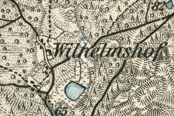
Map dates from ABT 1893. It covers an area of approximately 2.5 by 1.7 km (1.6 by 1.1 US miles).
Map image was adapted from Karte des Deutschen Reiches 1:100K, sheet 216 (Templin)
The following table shows which of the individuals included in this web site are connected to Wilhelmshof and over what time span they are found here.
| Surname | Given names and the range of dates the person was found in Wilhelmshof |
|---|---|
| Mührke / M(i)erke / M(ö/u/ü)r(c)k(e) / Merke |
 Johann Friedrich Siegesmund 1833..1836 Johann Friedrich Siegesmund 1833..1836 Louise 1836 Louise 1836 |