Mitch Blank's North-German Genealogy Site

Let me know if we are researching the same people or places.


Name and place indexes for this entire web site.

Information on just this family and region.

Introduction to this web site.
Copyright ©1998-2017 by Mitch Blank
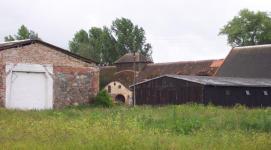
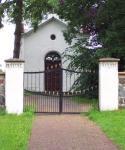
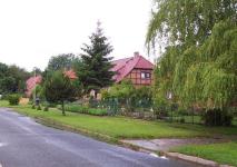
Lindhorst
Kreis Uckermark/Prenzlau, Brandenburg
(Click on picture for larger image)
Related Families in Lindhorst
Navigation
Let me know if we are researching the same people or places.
Name and place indexes for this entire web site.
Information on just this family and region.
Introduction to this web site.
This page created July 21st, 2001, updated July 3rd, 2013
Kreis Uckermark/Prenzlau, Brandenburg
(Click on picture for larger image)
| |
| To zoom out to a larger area map click here. | |
|---|---|
Map dates from 1884, updated 1911/1932. It covers an area of approximately 1.3 by 0.8 km (0.8 by 0.5 US miles).
Map image was adapted from 1:25K Prussian Landsaufnahme, page 2648
The following table shows which of the individuals included in this web site are connected to Lindhorst and over what time span they are found here.
| Surname | Given names and the range of dates the person was found in Lindhorst |
|---|---|
| Daberkow |
 Christian 1853 Christian 1853 |
| Mührke / M(i)erke / M(ö/u/ü)r(c)k(e) / Merke |
 Caroline Charlotte Dorothea Henriette 1862 Caroline Charlotte Dorothea Henriette 1862 |
| Neuman(n) / Newman(n) |
Ephraim Adolpf Friedrich 1858 |